PPGIS Practical Guide

Photo Credits: ENPI CBCMED
DESCRIPTION
PPGIS, or Public Participatory Geographic Information System, is a tool that empowers local communities to use geo-spatial information technologies (GIT) to understand urban issues and engage groups and actors in new participatory techniques.
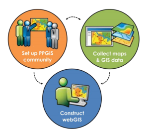
The document constitutes an exhaustive guide on how to achieve the creation of successful PPGIS communities in regards to a certain case study area. After an initial explanation of what a PPGIS community and its added value are, the guide proceeds to lay out step by step the creation of such a PPGIS community, covering elements from getting the right audience to how to manage the publication of maps and GIS tools and layers.
All of the theoretical information is supported by the example of application in Malta, one of the local case studies in the mare Nostrum project, which is used to illustrate the components of the PPGIS Practice.
RELEVANCE
Using PPGIS helps identify, understand and address spatial conflicts from a different perspective. These guidelines contain useful advice on how to start a PPGIS community, how to apply it and how to extract the most value for urban planning and design.
LINK
SOURCE
Integrated Resources Management Co Ltd IRMCo, Malta
LANGUAGE
English
YEAR
2015


